Sulphur Springs and Hopkins County weathered Saturday’s storm with minimal to moderate property damages reported overall, county emergency management officials reported Monday. One barn was reported to authorities as having been damaged by a tree, according to county reports.
At least one Suphur Bluff resident reported seeing a funnel cloud that dropped three times, but that report as of Monday morning was unconfirmed, according the serve weather incident report compiled by county emergency management officials Sunday for May 18.
County officials began receiving storm reports around 3:15 p.m. Saturday, mainly of trees and power lines blown down by the whipping winds. City official also began receiving reports of a tree down on Park Springs Road around that time too.
County road crews worked through the day Sunday cutting and removing the debris from more than a dozen county roads to make them accessible to motorists. The majority of the roads impacted were in Precinct 4, although at least two each were noted in three other precincts too. Pieces of tree debris littered city streets as well. The railroad tracks on County Road 2403 too were reported to have trees down across them. A tree reportedly fell on County Road, where a barn was damaged, according to county emergency management officials.
City officials received reports of a few power lines down in the city. A utility pole reportedly fell down over FM 69 in Sulphur Bluff; and sparking of power lines were reported on FM 852, State Highway 11 and County Road 4784 as a result of the storm.
At least one temporary road closure was reported due to flooding. FM 71 west at FM 3134 reportedly had water over it Saturday.
Officials received a report of 0.41 inches of rain falling within 15 minutes in Cumby Saturday during the storm.
The South Sulphur River near Cooper was reported to be at 18.3 feet at 8:15 a.m. Monday, 2.3 feet above the flood stage for that area. Minor flooding was still occurring and expected to continue, with the river expected to fall to 17 feet by Tuesday morning.
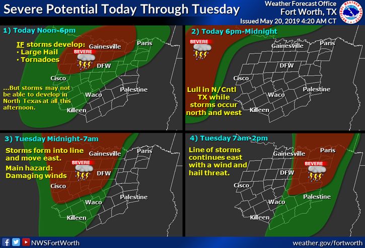
With more precipitation and potentially severe storms in the forecast for North and Central over the next few days, residents are recommended to pay close attention to the weather and their surroundings during and following weather events. If storms develop, they could produce hail and tornadoes, according to the National Weather Service.